Hampshire and The Atlantic Ocean - 1696
Base map derived from http://oceanmotion.org/pdf/OM_n_student_1.pdf - Lesson 12

Daily Progress
|

Warm Current
|

Cold Current
|

Antilles Current - A northwesterly current that meets the Florida Current in the Florida Straits where the two merge and become the Gulf Stream, The Antilles Current moves a significant amount of warm water into the Gulf Stream System.
|

Gulf Stream - The core of the warm Gulf Stream current is about 90km. wide with a peak velocity greater than 5 knots. When the Gulf Stream reaches the Grand Banks it branches into the North Atlantic Current and the Azores Current. The branch region is highly active and can have rapid change and lots of eddying activity.
|

North Atlantic Current - Moves warm Gulf Stream water pole-ward. It originates between the Grand Banks and the mid Atlantic Ridge. It is an extension of the Gulf Stream, and feeds the broader North Atlantic Drift, It is strengthened by the mixing of the Labrador Current and the Gulf Stream.
|

Labrador Current - (Blue Arrows)
Moves cold water into the Gulf Stream. |

North Atlantic Drift - Is the northern extension of the Gulf Stream and the North Atlantic current.
|

Azores Current - Is a branch of the Gulf Stream. Near the Grand Banks it has anti clockwise rotations in the northern half, and counter clockwise rotations in the southern half. As it flows southeast and starts to swing towards the southwest off the coast of Africa it becomes the Canaries Current.
|
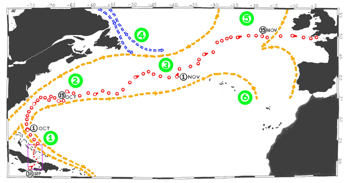
Crossing the Atlantic - 1696
On October 1, 1696, four days after slipping into the Antilles Current Hampshire had reached the Florida Straits and the Gulf Stream.
By October 15, the Hampshire had been at sea for 28 days sailing northward in the Gulf Stream and were being constantly nudged eastward in a long curving clockwise route along the eastern seaboard of the American Colonies. They were now ready for the long northeast run across the Atlantic to Plymouth, England.
A fortnight later on November 1, after 45 days at sea Hampshire had sailed the Gulf Stream to The Grand Banks (southeast of Newfoundland) where the Labrador Current interacts dynamically with the Gulf Stream. In this case the North Atlantic Current had pulled them more toward the north . For the next week they would also feel the eddying effects of the Azores current .
By Nov. 6th , their 50th day at sea, the Hampshire was being pushed northeast in the North Atlantic Drift. They started to sail a more easterly route.
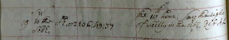
so that by Nov. 15th (Day 59) they were ready for the final leg to the English Channel. Four days later on Nov. 19th at “the 10th hour saw the light of Scilly in the N b E dust 4 L(eagues)” on the small archipelago of islands and islets lying 28 miles southwest off Lands End, Cornwall. Fletcher knew that winter gales could lash the islands at his time of the year. However, because of the mild effect of the North Atlantic Current frost or snow were almost non existent there!
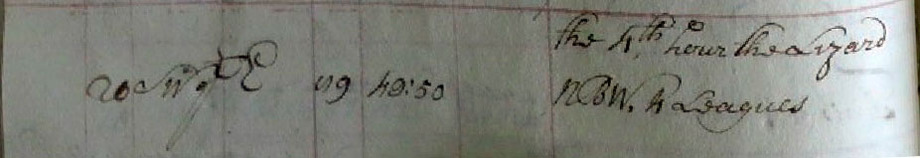
The next day at “the 4th hour” the Hampshire passed “the Lizard N b W, (at) 4 Leagues” off its port bow. This important landmark is a 14 mile by 14 mile peninsula known to all English mariners. The most southerly point of mainland England is near Lizard Point and all seaman knew that the hazardous coast and seas around the Lizard were referred to as the ‘Graveyard of Ships’ for a good reason. Fletcher had to be vigilant and a 4 Leagues buffer was a safe distance against disaster.

Then under a cloudy and rainy November 21st, 1696 -- after being a sea for 65 days ,the Hampshire “This morni’g Anchrd In Plymth Sound in Seaven fath. Water --“. She was home a last and safe in the Plymouth Sound (Map by Greenville Collins - 1693)
The next day The London Gazette reported the arrival thus “Plimouth, Nov. 22. Yesterday arrived here His Majesty’s Ship the Hampshire, with the Catherine of ??? from Jamaica;…”
Two weeks later, while anchored at the Downes off the coast of Kent, Fletcher wrote to the Admiralty about the terrible weather they had encountered at sea and the damage the Hampshire had sustained.